
 |
| Town Trails and Walkways Full Map |
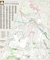
Pittsford Trails & Walkways
Within the Pittsford Town limits, there are over 85 miles of recreational and public pathways, including over 47 miles of trails and accessways and over 38 miles of sidewalks. Our pathways provide walkers, hikers and cyclists interesting destinations, quiet seclusion, and an enjoyable means to get some fresh air and exercise. We’ve mapped out 10 suggested routes below utilizing several of our trails and sidewalks. We also have an online interactive trails and sidewalks map that shows all of our trails and sidewalks, with links to trail maps.
Adobe Reader is needed to open the documents below; if needed, you may download the free program by clicking on the graphic at the bottom of this page.
To print a map, right click anywhere in the document and select print.
Cartersville / Simon Stone's Mill Trails |
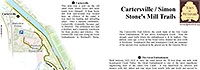 |
| Click map to enlarge |
Chatham Woods Trails |
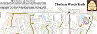 |
| Click map to enlarge |
Historic Erie Canal TrailsIncluding Nature Preserve Trail |
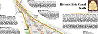 |
| Click map to enlarge |
Irondequoit Creek Trails |
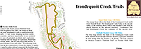 |
| Click map to enlarge |
Isaac Gordon Trails |
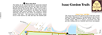 |
| Click map to enlarge |
Mile Post Trails |
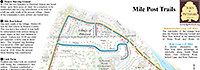 |
| Click map to enlarge |
Mitchell Trails |
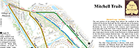 |
| Click map to enlarge |
Royal Coach Trails |
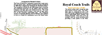 |
| Click map to enlarge |
Thornell Farm Park Trails |
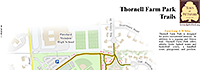 |
| Click map to enlarge |
Wynd's Woods Trails |
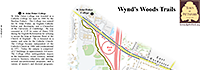 |
| Click map to enlarge |
To download the FREE Adobe Acrobat Reader, click on the logo below:
![]()
 Copyright © 2021 Town of Pittsford.